What Sardinia’s protected marine areas are, and what they restrict
Sardinia’s protected marine areas are stretches of sea placed under legal protection, each divided into zones with different rules on anchoring, fishing, diving and access. The island holds six of Italy’s marine protected areas, alongside the Maddalena Archipelago National Park in the north-east, which is protected under a separate framework.
Below we’ll see how the zoning works, where the areas are, and what visitors notice as a result.
How Sardinia’s marine protection is organised
Italian marine protected areas are established under national framework legislation on protected areas, dating from 1991. Each is divided into three concentric zones, tightening towards the core.
- Zone A, integral reserve. The most restricted. Navigation, anchoring, fishing and bathing are generally prohibited, and access is limited to authorised research or organised diving on fixed routes.
- Zone B, general reserve. Bathing is allowed. Navigation is capped at low speed, anchoring is permitted only where the seabed is sand and free of seagrass, and diving with breathing apparatus needs authorisation from the managing body.
- Zone C, partial reserve. The outer band and the least restricted. Taking, catching or damaging marine plants and animals remains prohibited throughout.
The pattern is the same across the island, but each area’s regulation sets its own detail. What is permitted in Zone B at one site may differ at another, so the rule that matters is the one published by the managing body, not a general summary. The archipelago in the north-east works differently again.
Where Sardinia’s protected marine areas are
The six marine protected areas run around the island’s coast, each attached to a different kind of landscape.
- Tavolara – Punta Coda Cavallo, in the north-east, spanning the municipalities of Olbia, Loiri Porto San Paolo and San Teodoro. Known for its dive sites and for the limestone mass of Tavolara that closes the horizon.
- Capo Testa – Punta Falcone, at the northern tip near Santa Teresa Gallura, one of the more recent designations.
- Capo Caccia – Isola Piana, off Alghero in the north-west, running along more than thirty kilometres of coast and paired with a regional land park.
- Isola dell’Asinara, in the north-west, both a national park and a marine protected area, on an island that held a prison until the 1990s.
- Penisola del Sinis – Isola di Mal di Ventre, on the central west coast in the municipality of Cabras.
- Capo Carbonara, at Villasimius in the south-east, extending along more than thirty kilometres of coast.
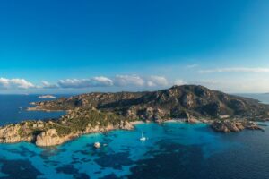
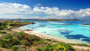
The La Maddalena Archipelago is not on that list, because it is protected as a National Park rather than a marine protected area. Established in 1994, it covers 62 islands and islets together with the waters around them, which is why its rules govern land and sea at once: no landing on the Pink Beach at Budelli, no removal of sand or shells anywhere, anchoring only on authorised buoys.
The reasoning behind those rules is easier to see underwater than on paper.
Why protection matters, and what it changes
Most of the restrictions come back to one plant. Posidonia oceanica is a flowering marine plant, not an alga, and it forms meadows across shallow Mediterranean seabeds.
Those meadows do three things at once. They are a nursery for juvenile fish, which is why fish are more numerous and larger inside protected zones than outside. They stabilise the seabed and feed the beaches: the pale sand of the archipelago is partly composed of fragments generated within the meadow system. And they store carbon at a rate comparable to terrestrial forest.
An anchor dragging across a meadow tears out plants that regrow at a few centimetres a year. A single summer of uncontrolled anchoring can undo decades. That is the whole reason for the buoy systems, the speed limits and the zoning.
What a visitor actually notices:
- Boats hold position rather than anchor freely in the more sensitive areas, or tie to fixed moorings.
- Some beaches cannot be landed on at all, and some can only be reached on guided visits with capped numbers.
- Nothing leaves with you. Sand, pebbles and shells stay where they are, and ports run checks.
- Fish are visibly more abundant when snorkelling inside a protected zone than immediately outside it.
None of this makes a day at sea more complicated. It explains why an operator who tells you where the boat cannot go is generally the one worth booking with.
Sailing a protected archipelago with Gite in Barca
We have been working the waters of the Maddalena Archipelago for over thirty years and leave daily from both Palau and La Maddalena, May to October.
Our full-day excursions operate under National Park rules aboard Lady Luna 3, which is why swim stops happen at authorised moorings and the Pink Beach is viewed from the water rather than walked on. We would rather explain that before you book than after.
Adult, child and infant prices are listed in full on the site. For anything about the itinerary, get in touch.
Glossary
- Marine protected area (AMP). A stretch of sea under legal protection, established under Italian framework legislation and divided into zones with graduated restrictions.
- Zone A, B, C. The three concentric bands of an Italian marine protected area, from integral reserve at the core to partial reserve at the outer edge.
- National Park. A broader designation covering land and sea together. The Maddalena Archipelago is protected this way rather than as a marine protected area.
- Posidonia oceanica. A flowering marine plant forming meadows on shallow seabeds. Fish nursery, sediment stabiliser and carbon store; the reason anchoring is restricted.
- Mooring buoy. A fixed anchoring point used inside protected waters, in place of dropping anchor onto the meadow below.